
Accessible Route of the Week: Dee Wright Observatory
New routes highlighted regularly!
by Hayley McClure
OAS Staff
Now is the time to explore the wonders of the Cascades! Located 15 miles west of Sisters, OR is one of the most awe inspiring vantage points of the Central Oregon Cascade range. From July through October, Highway 242 is clear of snow and open to vehicles for a wildly scenic drive from Sisters to McKenzie Bridge, OR. Along this magical journey from desert, through mountains, to a lush temperate forest, visit the Dee Wright Observatory for spectacular 360 views of the Cascade Range. Or just head to the top, take in the cool mountain air, and head back down. Either way you are in for an otherworldly experience!
OAS ROUTE OF THE WEEK
Dee Wright Observatory and the Lava River National Recreation Trail
LOCATION
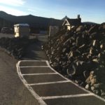
The Dee Wright Observatory is located 15 miles west of Sisters, OR along the McKenzie Highway (Highway 242). From Eugene, OR, follow Hwy 126 past McKenzie Bridge 5 miles, and turn right on Hwy 242. The Observatory is located 22 miles east of the Hwy 26 turnoff. The man made lava structure is easily recognizable from the road. Drive cautiously and allow for plenty of travel time to experience the drive. The historic winding highway is narrow and receives a lot of traffic during the summer.
PARKING
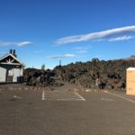
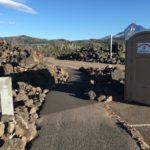
There will be parking on both sides of the highway, with a total of 3 ADA parking spaces, 2 of which are van accessible.
AMENITIES @ Dee Wright Observatory
- Parking includes ADA parking
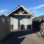
- ADA Restrooms: 2 permanent pit toilets, 1 portable toilet
- Accessible scenic look outs
- Accessible ½ mile accessible trail with midway resting bench


PUBLIC TRANSPORTATION
There is no public transportation to this observatory, as it is outside of city limits. People wishing to visit this trail will need to provide their own transportation.
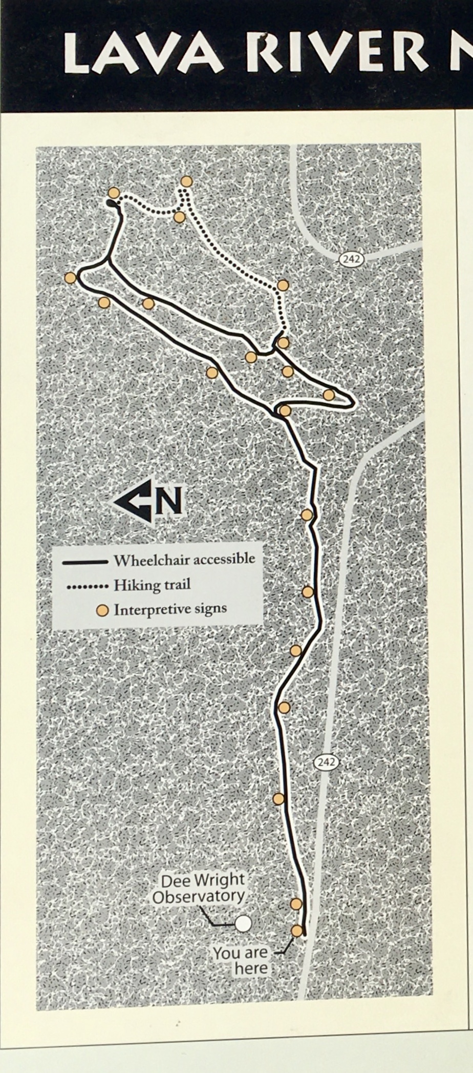 TRAIL RESOURCES and MAPS
For additional information about the Observatory and Recreation Trail, check out the Willamette National Forest site. You can find detailed maps of the landmark and trail at the bottom of the Dee Wright Observatory Page. There is also visual signage at the observatory location.
Lava River Recreation Trail Site
FACILITY CONTACT INFO
57600 McKenzie Hwy
Phone: 541-822-3381
Open: Mon – Fri 8am – 4:30pm, Closed Federal Holidays
TRAIL DESCRIPTION
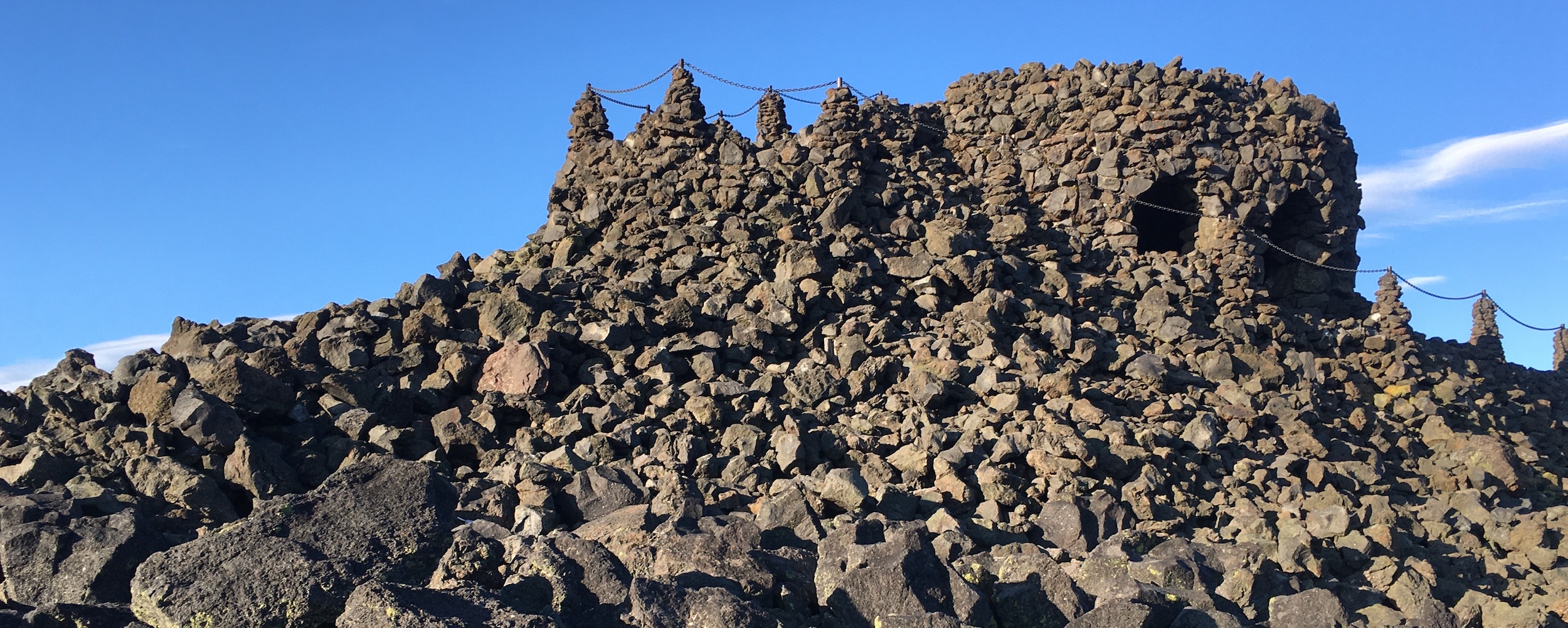
ROUTE 1 – Dee Wright Observatory
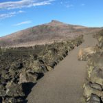
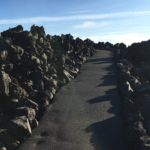
From the western parking area, the observatory path begins just past the restrooms and climbs upward toward a large man made structure made of the surrounding lava rock. As the smooth asphalt path ascends and switch’s back, hikers experience a new view in every direction, with vast lava fields, mountain peaks, buttes, and forests. At the top of the ¼ mile trail, the paved path transitions to an even, but rough lava floor as visitors enter the circular observatory. From the bottom floor of the observatory, arched open windows highlight and identify the surrounding peaks. To reach the upper level and observatory roof, follow the lava stair steps to the top. The upper level is not accessible to mobility devices. People using a mobility device may require assistance on the ascent to the main observatory floor.
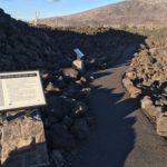
ROUTE 2 – Lava River Recreation Trail
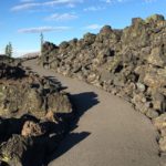
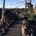
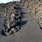
From the western parking area, head east along the highway, following the white painted pedestrian path toward the Observatory Entrance and Lava River Trailhead. The trail begins by flowing through an ancient lava field and past a “lava river.” Learn about the natural history along this interpretive, paved path. The 3.5 ft wide, rolling path makes a ½ mile lollipop shaped loop out and around interesting geological formations. At the first intersection, go either left or right to complete a short loop up and around, with view points and a resting area at the highest point.
TRAIL RATING
ROUTE 1 – Dee Wright Observatory – Moderate to Difficult for mobility devices
This trail is a short and steep ascent to the lower level of the observatory with grades consistently above 5% and up to 8%. Mid way up the path, is a flat, interpretive area to check out before the final ascent. On the final reach of this ¼ mile trail, the 3.5 ft wide path becomes more exposed with a steeper drop off to one side as you gradually climb the lava cone. Along the way, a large lava boulder has fallen and obstructed about 10inches of the path, making the path narrow at that pinpoint. Proceed with caution. People using a mobility device may need assistance.
ROUTE 2 – Lava River Recreation Trail – Moderate to Difficult for mobility devices
The Lava River trail is 3.5 ft wide with grades between 2-8%. The first portion of trail rolls slightly downhill with grades between 3-5%. At the intersection for the lollipop shaped loop, the trail ascends quickly at 6-8% grades as the trail switches back and climbs to a look out and resting area. Because of the shorter steeper climbs, this trail has a higher difficulty rating. People using a mobility device may require assistance.
TRAIL ELEMENTS
- Surface: Asphalt and Lava Stone
- Width: Trail width is 3.5ft wide
- Grade: 0 – 8% – fairly steep and steady climb to the observatory lookout. The ½ mile hiking trail is relatively flat with some shorter climbs up to 8%.
- Cross Slope: Mostly even with some cross slopes up to 2%
- Distances:
- Observatory – ¼ mile
- Lava River Trail – ½ mile
- Obstacles:
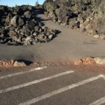
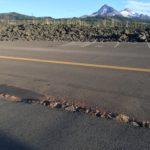
- There is one fallen lava rock on the path up to the observatory lookout, minimizing the trail to 2.5 – 3 ft wide. Pass with caution.
- There are some chips in the path due to erosion, and cause path to narrow
- The surface of the observatory is lava stone. It is rough with variable surfaces. Navigate slowly if needed.


ITEMS TO NOTE
- The observatory and pass is only open in the summer months after the spring thaw and prior to early season snow. Generally this is July through October, but depends on snowpack/fall from year to year.
- Temperatures are much cooler and it can be very windy at the observatory. Bring extra layers even on warmer days.
- This area can be very busy on weekends and mid – day, plan accordingly and be sure to practice social distancing while sharing the paths.
ADDITIONAL ROUTES ON THE THRIVE GUIDE
Tumalo Creek Trail @ Shevlin Park
Ray Atkeson Trail @ Sparks Lake
Disclaimer: Please practice social distancing while out on trails and paths. Please note, this content was designed for informational purposes and to help you determine if this route is best for you. Please, USE THIS INFORMATION AT YOUR OWN RISK. You are responsible for your own safety and knowing your own fitness levels. Oregon Adaptive Sports is not liable for any injuries as a result of visiting and using these suggested routes.